WEATHER UPDATE: AEMET issues further warning for heatwave
Maximum day-time temperatures in Xàbia are now forecast to reach around 36°c-37°c over the weekend, with night-time minimums remaining in the mid-20s.

Tuesday 10th August 2021 – PRESS RELEASE with Mike Smith
Translation of the Special Warning Notice issued by AEMET at 1.30pm today Tuesday 10th August 2021.
THE STATE METEOROLOGICAL AGENCY (AEMET) reports the following:
- Meteorological Phenomenon: Heat Wave
- Geographical Scope: All of Spain, except the Cantabrian area and a good part of Galicia
- Beginning of the Situation: Wednesday 11th August
- Duration: Until Monday 16th August
- Degree of Probability: Very high (greater than 80%)
- Description of the Meteorological Situation:
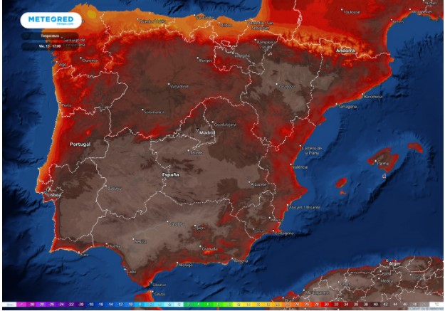
Throughout this week the continued incursion over the Peninsula and the Balearic Islands of a very warm air mass from North Africa, together with the strong sunshine typical of these days, is giving rise to a progressive thermal rise. The maximum and minimum temperatures will reach values well above normal values for this time of year in much of the Peninsula and the Balearic Islands, only the Cantabrian area and a good part of Galicia will not be affected by this situation. Due to the exceptionally high values that temperatures will reach in large areas of our territory throughout the week, AEMET issues this Special Notice due to heat waves.
Tomorrow, Wednesday, maximum temperatures will begin to exceed 35ºC in large areas of the south and centre of the peninsula and more locally in the Ebro valley and in the Balearic Islands. Temperatures around 40ºC will probably be reached from time to time in the Guadalquivir valley. From Thursday to Sunday the maximum temperatures will be above 35ºC in much of the Peninsula and in the Balearic Islands, with the exception of Galicia and the Cantabrian area, and will exceed 40ºC in large areas of the south and centre of the Peninsula and the Ebro valley and may even reach around 42-44ºC in the valley areas. Night-time temperatures will also be very high, around 25ºC in the south of the peninsula, the central zone and the Ebro valley and 20ºC in the rest of the areas.
Accompanying this heat wave episode, the presence of suspended dust is expected, due to the long journey of the air mass through the Sahara Desert before entering the Peninsula and the Balearic Islands. Likewise, at least until Thursday, there is a probability of storms in some parts of the eastern half of the peninsula, mostly dry but that could be accompanied by strong gusts of wind.
It is likely that, as of Friday, the warm mass from Africa will also begin to affect the Canary Islands, leading to a significant rise in temperatures and the beginning of a heat episode on the islands, while on Sunday or Monday, a decrease in temperatures could begin in the northwest of the peninsula that would end the episode of heat wave over the Peninsula and the Balearic Islands.
Given the uncertainty that still accompanies the evolution of this episode, AEMET will renew this Special Notice, updating the evolution of the heat wave as well as the influence in the Canary Islands for the next few days.

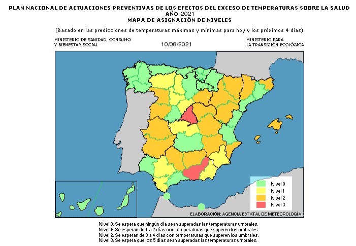
The province of Alicante is expected to be at LEVEL 2, a situation in which it is anticipated that the region will experience high temperatures above the normal threshold for 3 or 4 successive days. For the northern part of the province, the threshold is 37.9°c.


