Schools out but it remained dry: Are weather warnings missing the mark?
Schools closed for two days but Xàbia remained comparatively dry.

It has been a strange week, weather-wise. Our region has seen yellow- and orange-risk scenarios declared for the potential of heavy rain, schools have been closed for two days, and yet, aside from a brief downpour on Thursday evening, Xàbia has seen very little precipitation these past few days. With the disastrous Valencia floods still fresh in many minds, a disaster that took the lives of more than 240 people, there can be no doubt that caution needs to be taken when forecasts suggest inclement weather, but were the authorities a little too over-cautions in its decision-making?
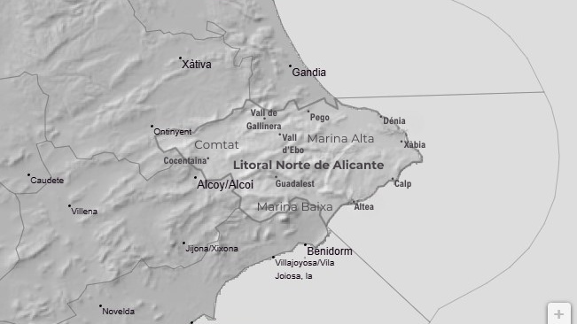
The ‘problem’ – if it can be considered as such – lies in the way that the state meteorological agency AEMET defines its risk areas. Xàbia is placed in an area known as ‘Litoral Norte de Alicante’ – the Northern Coast of Alicante – but it covers so much more than the coastline on which we are located. The risk area consists of the whole of the Marina Alta, the whole of Comtat to the west, and the northern half of the Marina Baixa from Albir up, a huge area that can be characterized by its mountain ranges and deep valleys, geographical features that can produce the type of weather that was being forecast.
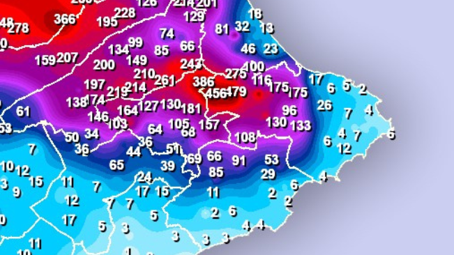
So those forecasts were actually pretty spot on. Over the past six days, several weather stations of this risk area have recorded enormous amounts of precipitation including Benialí and Benissili in the Vall de Gallinera (489.2mm and 468.0mm respectively) and the mountains north of Vall d’Ebo (Refugi La Figuereta – 329.0mm). In the specific case of Benialí, it received over 78% of all the rainfall its weather station has recorded this year in just a few days.
Even the likes of Pego, just 25km from Xàbia, received huge amounts of rain (232.8mm) over the past few days. Benigembla recorded 152.7mm, Alcalalí 152.2mm and Parcent registered 135.0mm. Contrast those figures with those recorded in Xàbia – which is the same risk area – where the weather station of Les Valls has collected 12.0mm in the first six days of this month, that of Asevi has registered 10.4mm, whilst the coastal stations of the Port and Platja de l’Arenal have recorded 4.4mm and 1.4mm respectively.
However, it’s not only direct rainfall that is the danger. As was clearly seen during the Valencian floods last year, the huge amount of rain that fell inland and filled the dry riverbeds and ravines followed the natural course to the sea and caused the most damage to towns and villages along their banks. This is also what is considered when issuing such warnings; avoid riverbeds and ravines is the common-sense advice and avoid unnecessary travel if at all possible.
With the ongoing affordable housing crisis forcing some teachers to live outside of Xàbia, in those areas that were more vulnerable to the heavy rain forecast, it made some sense that they shouldn’t be driving through those places that had the potential to be inundated by floodwater. Over-caution, maybe. But, after the tragedy in Paiporta last October, where 62 people lost their lives, many trapped in their vehicles, the risk couldn’t be taken lightly.
Finally, any heavy rain inland will need to drain somewhere, normally towards the sea, which means that normally dry rivers such as the Gorgos will suddenly become raging torrents and coastal areas where those rivers discharge into the sea, such as Xàbia, can also become vulnerable to flooding. It didn’t happen this time but it has done so before, as recently as October 2007.
So, do these weather warnings miss the mark? Not really. The risk was always there. The fact is that the risk area is so large and covers a diverse range of geographical features that shape those weather patterns on a local level that heavy rain can affect one area whilst another remains relatively dry. The potential is always there however and we should always remain vigilant.