AEMET issues warnings for the potential for heavy rain on Tuesday and Wednesday
The state meteorological agency warns that instability is likely to continue throughout the week.
UPDATED: 15:00 03/03/2025
The state meteorological agency AEMET has issued a series of risk warning of the potential for heavy rain in the Marina Alta region for Tuesday 4th March and Wednesday 5th March 2025.
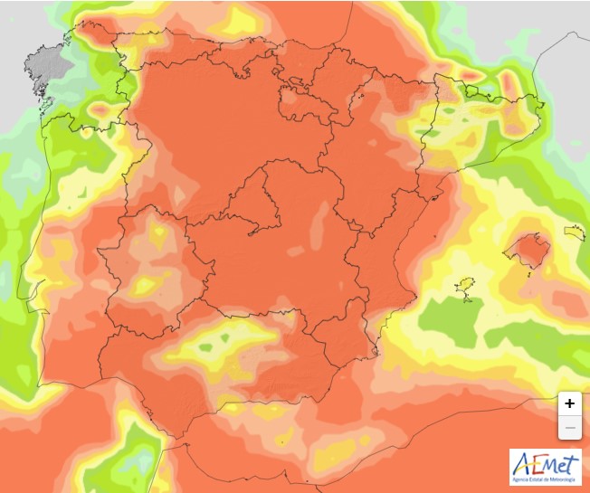
Tuesday 4th March 2025 – Orange · Heavy Rain (06:00-17:59)
From 6.00am on Tuesday 4th March, there is a 40%-70% probability of heavy rain in our area with a potential accumulation rate of 100mm in 12 hours at times, especially in the interior of the region. The risk will remain valid until 5.59pm the same day.
There are although a series of yellow risk alerts valid from midnight tonight for 40%-70% probability of heavy rain in our area with potential accumulation rates of between 20mm and 60mm. These risks remain valid until midnight tomorrow.
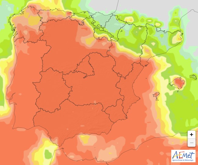
Wednesday 5th March 2025 – Yellow · Heavy Rain (00:00-23:59)
From midnight on Tuesday 4th March, there is a 40%-70% probability of heavy rain in our area with a series of yellow risk alerts throughout the day for accumulations between 20mm and 100mm. The risks remain valid until midnight the same day.
Tuesday 4rd March 2025
Wednesday 5th March 2025
Special Warning 06/2025 issued by AEMET stated:
In recent days there has been a progressive increase in instability, with a predominance of moderate winds from the east and northeast that bring a large amount of humidity to the Peninsula and the Balearic Islands, with widespread rainfall, locally strong and persistent, which will continue at least until Thursday and will probably extend to the rest of the week. Today the highest accumulations are expected in the interior of Malaga, as well as in the Comunidad Valenciana and south of Tarragona, where rainfall may be locally strong, or very strong, and persistent, with accumulations exceeding 100 mm in 12 hours. Also heavy or very strong showers are expected in western Andalusia, locally accompanied by storms and frequent hail.
On Tuesday, the highest accumulations will continue to be concentrated in the eastern third of the peninsula, particularly in the Comunidad Valenciana and southern Tarragona, with rainfall that could again be heavy and persistent, and which in areas south of Valencia and north of Alicante could accumulate amounts exceeding 100 mm in 12 hours. More occasionally, heavy showers will also be possible, locally accompanied by thunderstorms, around the Strait of Gibraltar and the mountains of western Andalusia.
The situation of instability is expected to continue on Wednesday and Thursday. The highest accumulations are expected in the provinces of Valencia and Castellón, exceeding 100 mm in 12 hours and more than 150 mm in 24 hours. In neighbouring areas such as the south of Tarragona and the north of Alicante, the amount could exceed 60 mm in 12 hours. On the other hand, a new increase in instability is expected around the extreme southeast of the peninsula, with showers that could be strong or very strong in areas of Almería and Murcia, also affecting parts of western Andalusia on Wednesday and the area around the Strait of Gibraltar and the Costa del Sol on Thursday.
Instability will continue from Friday onwards. Current information, within a context of growing uncertainty, indicates that the most affected areas will be the northeast of the peninsula, the Central System, the southwest of the peninsula and the Strait area, where rainfall will once again be locally strong and persistent.
What do the risk levels mean?
 AEMET will issue a orange warning when there is a significant risk of unusual weather phenomena with a certain degree of danger for usual activities, especially those outside, and the agency advises that the public be prepared and take the necessary precautions, whilst also staying informed of the most up-to-date weather forecasts. However, the issuance of such a warning does not mean that the situation will definitely happen but that there is an identifiable risk that it will do so.
 AEMET will issue a yellow warning when, although there is no risk to the general public, there is a risk for some specific activities, especially those outdoors, and advises that the public remains alert and stays informed of the most up-to-date weather forecasts. However, the issuance of such a warning does not mean that the situation will definitely happen but that there is an identifiable risk that it will do so.